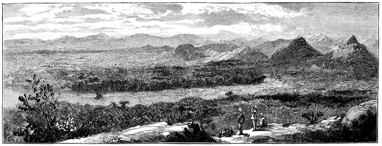
Looking south from behind Muang Haut, now Hot. Hallett, 1890, p. 64. This is the southern travel corridor, not the Wat Chan Elephant Trail. 6
The name makes a promise. Somewhere in the mountains between Chiang Mai and Mae Hong Son, the “Elephant Trail” is supposed to preserve the passage of elephants walked east to market. In one version, Mae Hong Son was a breeding centre. In another, the route dates to the town’s foundation. In the strongest telling, the trail was created for that very purpose.
Our investigation began with that last claim. It soon became clear that a better question was hiding inside it: how old is the name, and how did a particular mountain crossing acquire this story? A route can be old without its present name being old. Elephants can have used a path without elephant transport being the reason it was first opened.
The finding so far: The name has a late-1990s guidebook lead. The breeding-and-market explanation is directly documented in a December 2006 ride report. Earlier sources establish regional elephant travel and an elephant-catching tradition associated with Mae Hong Son. They do not yet establish who named the Wat Chan route, when it was first opened, or whether it was built expressly to move elephants to Chiang Mai.
Following the name backwards
The first firm breakthrough came from a source that would normally sit far below an academic monograph: a motorcycle forum. For the history of a nineteenth-century expedition, that would be weak evidence. For the history of a name circulating among riders, it is precisely the kind of evidence we need.
On 2 December 2006, a GT-Rider contributor using the name Pikey posted an account of a three-day trip. The opening explained that fellow rider SilverHawk had described the route as the Elephant Trail because Mae Hong Son had been a breeding centre whose elephants were walked to Chiang Mai for sale. The rider list identifies SilverHawk as Dave Early. The journey proceeded from the Chiang Mai side through Samoeng toward Mae Hong Son. 2
This does not make Early the inventor of the name. It makes him a named person in its documented transmission. The report tells us who supplied the explanation on that occasion; it does not tell us where he learned it. That distinction is the difference between finding a useful witness and declaring a mystery solved.
A second lead points further back. White Lotus’s listing for Christian Goodden’s Trek It Yourself in Northern Thailand explicitly mentions the Old Elephant Trail and identifies the print edition as Bangkok, 1999. The same listing has a separate 2006 release date. Those fields must not be confused. The book’s relevant pages have not yet been inspected, so 1999 remains the strongest bibliographical lead found here—not a demonstrated date of coinage. 1
By February 2014, the story appears in another riding forum. A contributor quotes a travel company, GreatHolidayCollection.com, for the claim that Mae Hong Son bred elephants subsequently walked to Chiang Mai. Another post assigns the trail an 1831 foundation date without supplying a historical reference. The additional repetition establishes circulation. It does not establish independent confirmation, and we cannot show that the 2014 account descended from the 2006 one. 3
A timeline of evidence for the name
1999 — Bibliographical lead. Goodden’s print edition is associated with the Old Elephant Trail in a publisher’s later listing. Book passage still to check.
2006 — Directly inspected occurrence. Pikey’s ride report supplies the name, the breeding-and-market story, and a named informant.
2014 — Further circulation. A rider quotes a travel company’s version; another post attaches the date 1831.
These are dates of identifiable references, not dates when the trail was made. Sources 1–3.
One name, several mountain corridors
Before testing the lore, we have to locate its subject. Modern descriptions attach “Elephant Trail” to the route through Samoeng and Ban Wat Chan, particularly the crossing west from Wat Chan toward Mae Hong Son. A modern recorded itinerary confirms this usage, while supplying no documentary basis for its historical explanation. 12
That is not interchangeable with every old journey between Chiang Mai and Mae Hong Son. The Pai approach comes from farther north; the Hot–Mae Sariang approach comes from the south. An account of elephants on either corridor cannot automatically be used as evidence for the Wat Chan crossing.
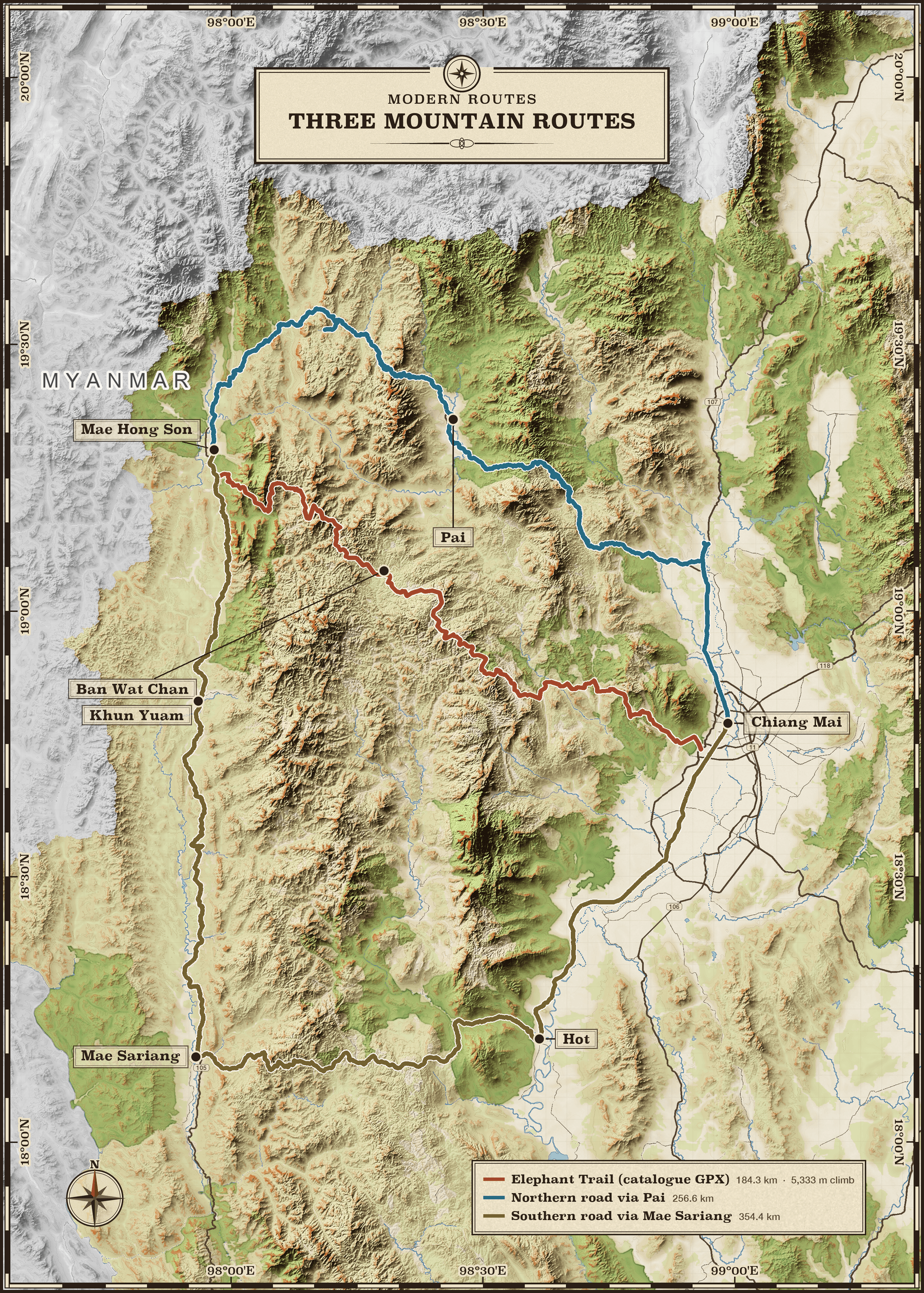
Three modern routes across real terrain. Static map rendered by Larkin’s mapping service in Survey Relief. Rust: the “Old Elephant Trail” GPX from the Chiang Mai Dirt Bikes catalogue, including its approach from the Chiang Mai outskirts. Blue: modern road routing through Pai. Ochre: modern road routing through Hot, Mae Sariang and Khun Yuam. The two road lines use OpenStreetMap geometry routed with OSRM; they include town approaches and local connectors. These lines locate today’s routes, not the precise paths of the 1831 expedition or Coultas’s 1926 journey. The catalogue GPX is simplified, so its line does not preserve every trail bend. Map data © OpenStreetMap contributors; © OpenMapTiles; Copernicus DEM © ESA. Route data retrieved 11 November 2026.
The elephant story is older than the trail evidence
Mae Hong Son does have an elephant-origin tradition. The provincial commerce office’s account dates an expedition to 1831. Chao Kaeo Mueang Ma was sent from Chiang Mai to survey the western region and catch wild elephants for training. The account places the party’s approach through Pai, followed by movement toward the Pang Mu area. 4
Two details resist the compressed modern story. Catching wild elephants is not the same activity as breeding them. And an expedition passing through Pai does not identify the Samoeng–Wat Chan route. The same account dates Mae Hong Son’s establishment as a muang to 1874, distinct from the 1831 expedition and village origins. The official account is also retrospective: it preserves a founding tradition, not an expedition diary written in 1831.
None of that proves elephants never crossed via Wat Chan. A party could travel out one way and return another; later traffic could use a different path. But those are possibilities, not evidence. The town’s elephant association cannot supply the missing itinerary.
Academic work adds further complications. In his study of Khun Yuam and regional identity, Niti Pawakapan examines competing settlement histories involving traders, migrants, frontier politics and logging. His discussion includes the elephant-catching account, but also Ronald Renard’s interpretation of the 1831 mission in the context of Chiang Mai’s relations with Red Karen or Kayah power. The region’s settlement was not reducible to a single animal-supply operation. 5, pp. 30–32
One possible explanation is that the town’s origin story became attached to an old route and gradually took on the specificity of a road-building story. That would explain the neat fit between 1831, elephants and the trail. It remains a hypothesis about how the lore developed, not a demonstrated chain of borrowing.
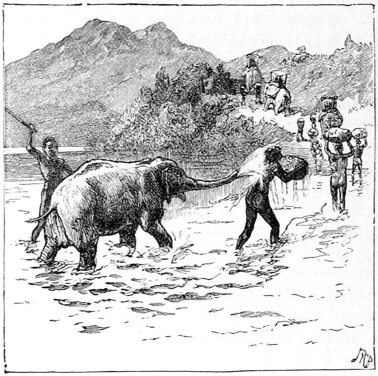
“The little elephant’s fun,” Hallett, 1890, p. 148. A period illustration of elephant travel elsewhere in his narrative—not a view of the Mae Hong Son–Wat Chan crossing. 6
What the old travellers actually establish
Holt Hallett’s A Thousand Miles on an Elephant in the Shan States, published in 1890, is an obvious place to look. The title promises exactly the right animal and period. Its geography requires closer attention.
Chapters IV–VI take the reader through Maing Loongyee, the Mae Sariang area, east across the Bau plateau to Muang Haut. Subsequent chapters continue toward Chiang Mai, including boat travel. The map below documents that southern approach. It cannot authenticate a separate crossing farther north simply because elephants feature in the same book. 6
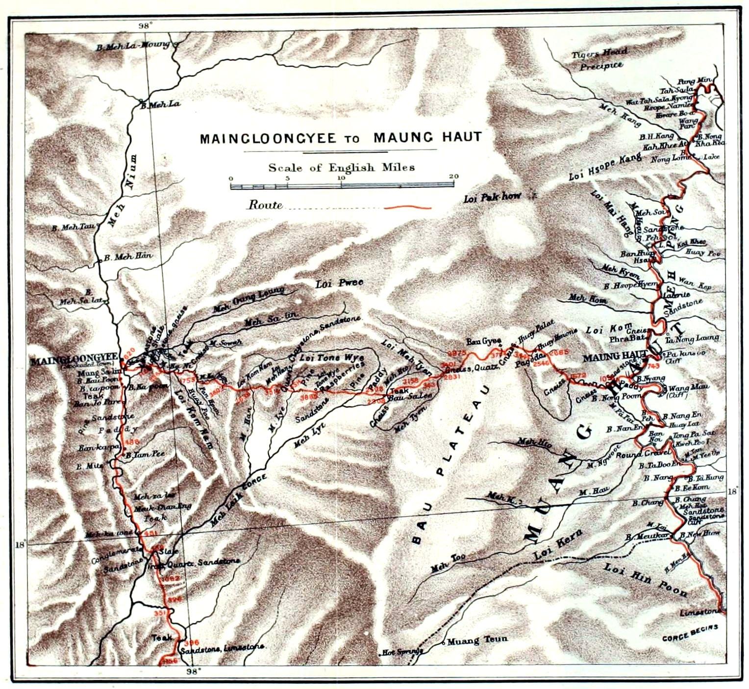
Historical map, 1890. “Maingloongyee to Maung Haut,” plate adjacent to pp. 42–43. The red line belongs to the original map. This is evidence for the Mae Sariang–Hot corridor, not a map of the modern Elephant Trail. Click for the full-resolution source. 6
A more direct account of the Mae Hong Son circuit comes from British consul W. W. Coultas in 1926. He travelled from Chiang Mai through Pai, Mae Hong Son, Khun Yuam and Mae Sariang, returning through Hot. The transcription of his report describes tracks rough enough that mahouts had to cut vegetation to get the elephants through. Outside the settlements, he reported no roads or cart tracks. 7
That is strong evidence for elephants moving through a difficult regional transport network. It is not evidence that the Wat Chan trail was created to take sale animals east. Coultas also adjusted his approach to Pai because of wet conditions—a reminder that historical travel was not always one fixed line on a map.
Other records point westward. A British Library catalogue caption for a James George Scott photograph, dated to the 1890s, describes the Ta Taw Ma ferry across the Salween on a route six bullock marches from Mehongson. Mae Hong Son was a junction in a wider world of crossings, markets and settlements, not simply the western endpoint of a road to Chiang Mai. 8
Does the trail live up to the lore?
Documented: elephants travelled in this regional network
Period travel accounts support this. An elephant association is historically plausible and has substance beyond the modern name.
Preserved as tradition: Mae Hong Son’s settlement origins involved elephant capture
Official and academic accounts discuss the tradition. It does not itself establish a breeding centre, a particular return route, or road construction.
Not demonstrated: this particular trail was built to take elephants to market
No contemporary source examined here supplies the required link between purpose, date and the Wat Chan alignment.
Origin still open: who first used the English name?
The 1999 bibliographical lead and 2006 occurrence narrow the search. Neither establishes who first used the name, or whether it translates an older local name.
The fair verdict is therefore narrower than either a romantic endorsement or a debunking. The name evokes a real transport world. The precise founding explanation remains lore. Nothing found justifies calling it an invention by a particular guide, rider or tour company; equally, repetition does not turn it into an established nineteenth-century fact.
The missing link is now a manageable research question
The next useful step is to inspect the trail chapter in Goodden’s earliest available edition and compare later editions. Does it explain the name? Does it cite an informant, a map, a local term or an older publication? A secondary reference points to page 328 in a 2000 edition, but that page has not yet been checked. 11 Early trekking guidebooks and dated editions of regional maps could then show whether the name was already established or was being introduced.
The 2006 report also creates an oral-history lead: the source of the explanation attributed to Dave Early. Asking where he encountered it would be more productive than asking whether elephants once travelled in northern Thailand. Karen and Shan residents along the route could supply local names and remembered uses that English travel literature leaves out. Those interviews would need dates, locations and attribution; this investigation has not conducted them.
For the older alignment, telegraph records are promising. Coultas describes a Chiang Mai–Mae Hong Son telegraph connection, while a later WWII history associates the old trail with that line but explicitly flags the relevant claim as needing a reference. A dated survey could connect places in a way that the current narrative cannot. 7 11
Until then, the best description is also the most interesting: an old mountain corridor with a documented modern name, an authentic regional elephant history, and an origin story whose crucial geographical link is still missing.
Research notes and unresolved checks
This article develops a web and digitized-source investigation begun with the question of whether the route was created for elephant transport. It does not report fieldwork, interviews, a complete archive search or a georeferenced reconstruction. English and Thai searches included modern and older spellings such as Zimmé, Chiengmai, Mehongson, Mehongsawn and Muang Houngson. Search-engine publication dates and forum membership dates were not treated as dates of historical events.
The 2006 post improves on the initial investigation, which located the breeding story in a 2014 quotation. The earlier occurrence is now directly inspected. The Goodden reference is still bibliographical: finding a title in a later catalogue is weaker than reading the relevant passage in the original edition.
One disagreement remains unresolved. Subrahmanyan’s dissertation, p. 51, describes a 1934 Thai report as indicating no connecting postal or telegraph stations, whereas Coultas records services in 1926. The original Thai report—National Archives of Thailand, SR.0201.14/10, 7 July 1934—needs checking for scope and wording before the discrepancy can be explained. 9
Richardson’s 1829–1835 journals are a further archival lead, cited by Grabowsky as British Library manuscript 30,354. Their contents were not inspected here. 10 Historical travel writers are useful observers of routes, but their commercial, colonial and ethnic assumptions also shape their accounts.
Sources and image credits
Numbered citations lead to the evidence used. “Not inspected” identifies leads, not evidence silently treated as confirmed. All three historical images come from Hallett’s 1890 public-domain volume via Project Gutenberg; they are retained with their original geographical scope. The terrain map was rendered for this article using Survey Relief, catalogue GPX and modern OpenStreetMap road geometry; see its caption for provenance and limitations. The evidence timeline was created for this article. No AI-generated historical scenes are used.
1. Goodden and the 1999 bibliographical lead Christian Goodden, Trek It Yourself in Northern Thailand. White Lotus lists “PRINT: Bangkok 1999” and describes the Old Elephant Trail. The listing also has a separate 2006 release field. The relevant book pages were not inspected; 1999 is a bibliographical lead, not a verified first coinage.
2. The breeding and market story in 2006 Pikey, “Elephant Trail – Chiang Mai – Mae Hong Son offroad,” GT-Rider, 2 December 2006, opening post. Full page retrieved and inspected. Reports a journey on 29 November–1 December and attributes the explanation to SilverHawk, identified in the rider list as Dave Early.
3. The story circulating in 2014 2wheels, “On the Elephant Trail (for the first time),” Ride Asia, 11–12 February 2014; especially posts 7 and 16. Post 16 attributes the breeding-and-walking claim to GreatHolidayCollection.com. That original travel-company page was not recovered.
4. Mae Hong Son’s official founding account Mae Hong Son Provincial Commerce Office, Thai provincial information page. Retrospective account of the 1831 expedition, explicitly travelling through Pai. Evidence for the published founding tradition, not a contemporary expedition record.
5. Competing histories of settlement Niti Pawakapan, “Once were Burmese Shans: Reinventing Ethnic Identity in Northwestern Thailand,” in Alexander Horstmann and Reed L. Wadley, eds., Centering the Margin (Berghahn, 2006), pp. 27–52, especially 30–32 and 43–44. Text inspected through an accessible transcription; JSTOR provides the chapter record.
6. Hallett’s travelogue and illustrations Holt S. Hallett, A Thousand Miles on an Elephant in the Shan States (1890), chapters IV–VIII and XXVIII. Public-domain volume digitized by Project Gutenberg. Historical map: plate adjacent to pp. 42–43; landscape: p. 64; elephant illustration: p. 148. These are not images of the Wat Chan trail.
7. The 1926 consular circuit W. W. Coultas, Report of a Tour of the Salween District in Siam in 1926, transcribed by Frans Betgem, published online 20 September 2018, updated 12 March 2022. Sections “Itinerary,” “Communications,” and “Posts and Telegraphs.” Original archival report not inspected.
8. An early route west of Mae Hong Son British Library, Photo 92/2(55), James George Scott collection, dated 1890s. Catalogue caption identifies Ta Taw Ma ferry on the Salween and a route six bullock marches from Mehongson. Caption inspected; photograph not reproduced here.
9. The 1934 Thai archival lead Arjun Subrahmanyan, Reinventing Siam: Ideas and Culture in Thailand, 1920–1944 (PhD dissertation, University of California, Berkeley, 2013), p. 51 and note 90. Cites National Archives of Thailand, SR.0201.14/10, Kaeo Singhakachinthara to the government, 7 July 1934.
10. Richardson’s early journals Volker Grabowsky, “Forced Resettlement Campaigns in Northern Thailand During the Early Bangkok Period,” Journal of the Siam Society 87 (1999), bibliography p. 77: David Richardson, Journal of Missions to the Shan States, Siam and Ava, 1829–1835, British Library manuscript 30,354. Manuscript not inspected.
11. A telegraph alignment to investigate World War 2 in North Thailand, “Ban Kat: Appendices.” Connects the old trail with a telegraph route but marks the relevant assertion “Ref needed.” Also cites Goodden, Trek It Yourself, a 2000 edition, p. 328. A lead, not corroboration.
12. Modern route identification Per Andersen, “Elephant trail Wat chan – Mae hong son,” recorded March 2023. Used to identify the modern corridor, not to establish its historical purpose.
Research is current to 11 November 2026. “Earliest found” means earliest identified in this investigation, not earliest surviving or earliest ever used.